
Alaska's Highways
Throughout the state, over 17,000 miles of public roads connect Alaska’s dramatic landscapes - from the Canadian border to the coastline, the remote reaches of the Arctic Circle to our largest cities, meandering through alpine valleys, tundra, forests, and alongside glaciers and rivers. And while that may seem like a lot of miles, at 365 million acres, most of this great state is still only accessible by water or air. The part of Alaska that is accessible by road is made up of a network of incredibly scenic highways that travel from the northern reaches of Prudhoe Bay in the Arctic, through the Interior and Southcentral regions, and down to the Haines & Klondike Highways in the Inside Passage by way of Canada.
Alaska’s highways are a road tripper’s dream come true, connecting colorful towns to endless adventure – with plenty of opportunities to stop and stretch your legs along the way. Whether you’re driving from Canada to Alaska, Anchorage to Fairbanks, Valdez to Homer, or just looking for a day trip, Alaska’s highways are exceptional and unique. Here’s our list of some of the highways you can explore on your next Alaska road trip:
The Alaska Highway
Begins: Dawson Creek, British Columbia
Ends: Delta Junction, Alaska
Distance: 1,387 miles
Best For: The Ultimate Road Trip
The Alaska Highway is one of the most impressive highways in North America. It’s open year round and is a paved highway running 1,387 miles from Canada to Alaska. It begins at mile 0 in Dawson Creek, British Columbia, Canada and travels north to the Yukon Territory of Canada, and west to Delta Junction, Alaska.
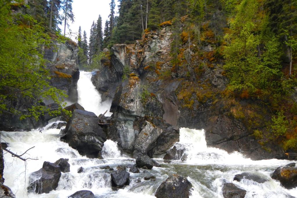
Often called the Alcan, a shortening of Alaska-Canada, it was an engineering feat built after World War II, and one of the largest construction projects since the Panama Canal. It’s one of the most scenic highways in the world, with mountains and stunning scenery welcoming you along each mile (or kilometer). The Alaska Highway covers a wide range of landscapes from national parks, valleys, mountain ranges, rivers, lakes, forests, and tundra, and boasts exceptional views and wildlife sightings. There are viewpoints, rest areas, locations for fishing, hiking, recreational activities, and more along the way. It’s considered a safe and stunning, scenic highway!
Wildlife surrounding the highway abounds, and bison are so common towards the northern stretch of the drive that they may seem as common as cattle by the time you’re through! Travelers should be aware that brown and black bears, caribou, moose, bison, and other wildlife are ever-present in the area. You will likely see them on your drive, so always exercise caution and be alert when not only driving, but also exiting and entering your vehicle.
Mile postings dot the highway, guiding drivers along the road, and the speed limit ranges from 50 mph to 65 mph. The road is paved, but loose rock is common. Food, fuel, and accommodations are available along the highway, with services located every 50-100 miles. While the highway is open year-round, most businesses are seasonal, so be sure to verify that accommodations are available before planning your trip. Because the highway travels across international borders, you will need your passport to travel its full length. Learn more about driving North to Alaska on the Alaska Highway.

Dalton Highway
Begins: Livengood
Ends: Deadhorse / Prudhoe Bay
Distance: 414 miles
Best For: Off-the-grid guided road trips
Often referred to as the highway on top of the world, the Dalton Highway is a gravel-covered scenic byway spanning 414-miles, beginning 78 miles north of Fairbanks, and ending in Deadhorse. It parallels the northernmost section of the Trans-Alaska Pipeline, and even crosses into the Arctic Circle!
The highway is unpaved and considered to be a challenging highway to travel. While it certainly boasts some of the most beautiful and scenic views in the state, the road is primarily used by large trucks and is not recommended to travel for leisure for most visitors. Services along the highway are few and if mechanical issues arise, help can be hard to find. In fact, many rental car companies in Alaska prohibit the use of the Dalton Highway for this reason. There are, however, tour companies that lead trips along the highway and offer proper equipment and access to services, making stops at the top sights along the way. Read more about driving the Dalton Highway in our Insider's Tips for Exploring the Dalton Highway.

Denali Highway
Begins: Paxon
Ends: Cantwell
Distance: 135 miles
Best For: Scenic Off-The-Beaten-Track Views
Not to be confused with the Denali Park Road that heads into the heart of Denali National Park, the Denali Highway was opened in 1957 as the first road access to the entrance of the park. The Parks Highway has been the access point to Denali National Park since 1971, but the Denali Highway still stands as one of the most iconic and scenic drives in the state. Beginning in Paxon on the Richardson Highway and ending at Cantwell on the Parks Highway (30 minutes south of the entrance to Denali National Park), the rugged Denali Highway offers a unique adventure through vast, scenic landscapes.
The road is mostly unpaved and is open seasonally, typically mid-May through October 1. Be sure to check the highway status before your trip. There are very limited services along the way and limited cell service. Due to the rugged, often bumpy graveled road conditions and remoteness, many car rental companies don’t allow rental cars on this road. Check with your rental car company if to see if they have any road restrictions before planning a trip on the Denali Highway.
The road travels east to west along the Susitna and Nenana Rivers on the south side of the Alaska Range. This area is the traditional homelands of the Athabascan Peoples, where evidence of human habitation dates back over 10,000 years. Off of the Denali Highway, visitors can explore the Tangles Lakes Archaeological District, a popular spot for camping and boating, where over 500 archaeological sites have been found. The road climbs to an elevation of 4,086 feet at Maclaren Summit, granting stunning mountain, river, and alpine views as far as the eye can see.
Moving through boreal forests, tundra, and taiga, the road also follows gold miners’ trails that date back over 100 years to the Alaska Gold Rush. Views from the road include the Wrangell Mountains; Maclaren Glacier; the Nenana, Maclaren, and Susitna Rivers; and the mighty Alaska Range, including views of the tallest mountain in North America – Denali – on clear days.
Wildlife here includes bears, moose, fox, wolves, and a wide variety of birds. The Nelchina caribou herd also migrates through the area. Northern hawk owls and other raptors enjoy the Arctic hare population, while beavers, muskrats, waterfowl, and shorebirds can be found near the many ponds, lakes, and streams by the highway.
While the road can technically be driven in one day, there are a few remote lodges and two first-come, first-serve BLM campgrounds along the way that make Denali Highway the a great option for an overnight adventure. Fishing, sightseeing, bicycling, canoeing, and hiking are all popular activities. Canoe routes are accessible from the highway, as Tangle Lakes and the Delta Wild & Scenic River offer great launching areas for visitors. When it comes to hiking and biking, trails can be seen right off the highway, to be enjoyed for many miles.

Edgerton Highway
Begins: Richardson Highway
Ends: Chitina
Distance: 36 miles
Best For: Mountain views and access to the McCarthy Road
The Edgerton Highway, also known as the Edgerton Cutoff, is a short stretch of scenic highway connecting the Richardson Highway to the small town of Chitina. The road is open year-round and paved, ideal for a day trip from the Richardson Highway. It is also the only access point for the McCarthy Road that leads into Wrangell-St. Elias National Park.
The highway leads southeast from the Richardson Highway, south of Glennallen and Copper Center. Views of the braided Copper River and the Wrangell Mountains, the bucolic farmlands of Kenny Lake, and access to Liberty Falls State Recreation Area are highlights along the way. The road ends in Chitina, a small historic railroad town at the confluence of the Copper and Chitina Rivers. From Chitina, the 60-mile rugged McCarthy Road leads into the heart of Wrangell-St. Elias National Park to the town of McCarthy and Kennicott Mines National Historic Landmark.
A few amenities are located along the way including a couple of lodging options, an RV Park, a small mercantile with gas, and a several campsites at Liberty Falls State Recreation Area. The town of Chitina has a small hotel and a couple of dining options. Much of the area is Alaska Native owned land, so be sure to respect private property.
Elliott Highway
Begins: Fox (north of Fairbanks)
Ends: Manley Hot Springs
Distance: 151 miles
Best For: Access to the Dalton Highway and Manley Hot Springs
Located just northwest of Fairbanks, the Elliot Highway takes drivers through a landscape of panoramic views, with ample wildlife viewings, hiking options, views of the Trans-Alaska Pipeline, and access to the Dalton Highway. The road ends at the small town of Manley Hot Springs on the Tanana River.
This road is half paved, half gravel and is open year-round. Along the way, visitors will find historic gold mining sites, scenic views of the White Mountains, river access for boating and fishing, and hiking at Wickersham Dome and Grapefruit Rocks. In winter, snowshoeing, snow machining, and skiing are popular in the area. Aurora viewing is popular from Elliott Highway, particularly at Wickersham Dome, as its northern location and dark skies provide ideal conditions for northern lights viewing. At Milepost 73 of the Elliot Highway is the start of the Dalton Highway, also known as the Haul Road, the rugged 414 mile road that travels north through Alaska’s Arctic region.
The highway moves through the traditional homelands of the Athabascan People, and the Athabascan town of Minto is located off of the Elliot Highway. There are two first-come, first-serve BLM campgrounds along the way, along with one public use cabin that is reservable in advance. The small town of Manley Hot Springs, located at the end of the road, provides lodging at the historic Manley Roadhouse, along with access to fishing, boating, and hiking.
Glenn Highway & Tok Cutoff
Begins: Anchorage
Ends: Tok
Distance: 328 Miles
Best For: Visiting the Mat-Su and Copper River Valleys, connecting the Alaska Highway with Southcentral Alaska
This 328 mile-long scenic byway connects to the Alaska Highway, running west from Tok to Anchorage and Southcentral Alaska. It boasts gorgeous views of the Chugach, Wrangell, Talkeetna, and Mentasta Mountain ranges, and passes through Tahneta Pass into Palmer – which hosts the Alaska State Fair in late summer.
Wildlife viewing on this drive is plentiful. Moose, caribou, tundra swans, Canada geese, and ducks travel near the highway during different times of the year. Matanuska Glacier is located at mile 102 on the highway and is accessible by car, with guided glacier trekking tours along with campsites and lodging in the area.
Lake Louise State Recreation Area is located off the Glenn Highway and is popular with locals and tourists alike! It boasts a breathtaking campground on the shores of Lake Louise, with campsites, two lodges, boat launch, and stunning views. As you continue on, you’ll pass through Glennallen and then travel north alongside the mighty Copper River, with views of the towering peaks of Wrangell-St. Elias National Park to the east.

Haines & Klondike Highways
HAINES HIGHWAY
Begins: Haines, Alaska
Ends: Haines Junction, Yukon Territory, Canada
Distance: 146 miles
KLONDIKE HIGHWAY
Begins: Skagway, Alaska
Ends: Dawson City, Yukon Territory, Canada
Distance: 544 Miles
GOLDEN CIRCLE ROAD TRIP (Haines/Skagway Loop)
Distance: 350 Miles
Best For: Inside Passage road trip
The Haines and Klondike Highways are the only Alaska highways in the Inside Passage that connect to the Alaska road system (by way of Canada). The Haines Highway begins in Haines, running 146 miles northwest to Haines Junction, Yukon Territory on the Alaska Highway. For those interested in the Golden Circle Road Trip route, you’ll head east on the Alaska Highway about 105 miles through Whitehorse to Carcross Cutoff, where you’ll connect with the Klondike Highway. Once on the Klondike Highway, you’ll head south about 100 miles to Skagway. From there, you can take the Alaska Marine Highway Ferry back to Haines or any of the other communities along the ferry route. You'll cross the Alaska/Canada border twice on this road trip - once while heading north on the Haines Highway, and again heading south on the Klondike Highway.
Once used for trading posts and gold rush traveling points, the highways offer a chance for you to step into history with many historical gold rush sites along the way. Traveling for an hour on the Alaska Marine Highway will give you stunning views of the coastline, while crossing international borders through Canada will bring you to scenic, mountainous views and even take you by the Carcross Desert sand dunes. Many lakes and rivers can be seen along the route, including Emerald Lake, where you can stop for a photo opportunity of the lake’s beautiful turquoise waters.

Parks Highway
Begins: Anchorage
Ends: Fairbanks
Distance: 358 miles
Best For: Accessing Denali National Park
This scenic byway was completed in 1971 and connects Alaska’s two largest cities, Anchorage and Fairbanks. The road is fully paved and open year-round! Those traveling during summer months can enjoy basking in the midnight sun with spectacular sunlit views. During the autumn months, incredible autumnal foliage rivals even New England’s scene, as alpine landscapes light up with yellow, orange, and red tundra and trees. It’s a popular route for those seeking out the northern lights in the winter months, as well. If traveling during the winter, be sure to check local weather conditions and bring emergency gear.
Traveling north through Willow and Talkeetna will give you the opportunity to try out a dog sledding tour - any time of year. Many Iditarod competitors have kennels in this area and offer kennel and dog sledding tours in their off-season. Talkeetna offers accommodations, food, and other recreational activities and is a great place to spend the night along your travels. Heading north, you’ll pass by the one and only Denali National Park and Preserve. You’ll be able to enjoy views of the tallest mountain in North America, Denali, long before arriving at the park, and will have direct access to the entrance to Denali National Park from the highway.
You’ll see some of the most beautiful views in the state along this road and can enjoy hiking trails, whitewater rafting on the Nenana River, wildlife viewing, and more. The Parks Highway ends in Fairbanks - home to the University of Alaska Fairbanks campus and several excellent museums highlighting Alaska Native culture and state history. Northern lights viewing, dog sledding tours, snowmachine tours, Chena Hot Springs, and sightseeing tours are also popular in the area.

Richardson Highway
Begins: Valdez
Ends: Delta Junction
Distance: 368 miles
Best For: Connecting the Interior to the coast in Southcentral Alaska
The Richardson Highway is a scenic byway that begins in Valdez and ends at the end of the Alaska Highway in Delta Junction. It runs 368 miles, south to north, and is not only the oldest highway in Alaska, but the only highway to access Valdez in Prince William Sound.
The highway parallels the incredible Trans-Alaska Pipeline, and you can enjoy viewpoints of this impressive engineering feat along the way. The highway also provides access to Wrangell-St. Elias National Park – the largest national park in the United States. Stop by the Wrangell-St. Elias National Park Visitor Center in Copper Center or plan a side trip to spend a few days in McCarthy, located within the park. Incredible scenic experiences await on this drive, including passing through Keystone Canyon, Thompson Pass, and alongside Worthington Glacier near Valdez. The highway doesn’t only offer views in summer – in the winter, it is a popular route to view the northern lights.

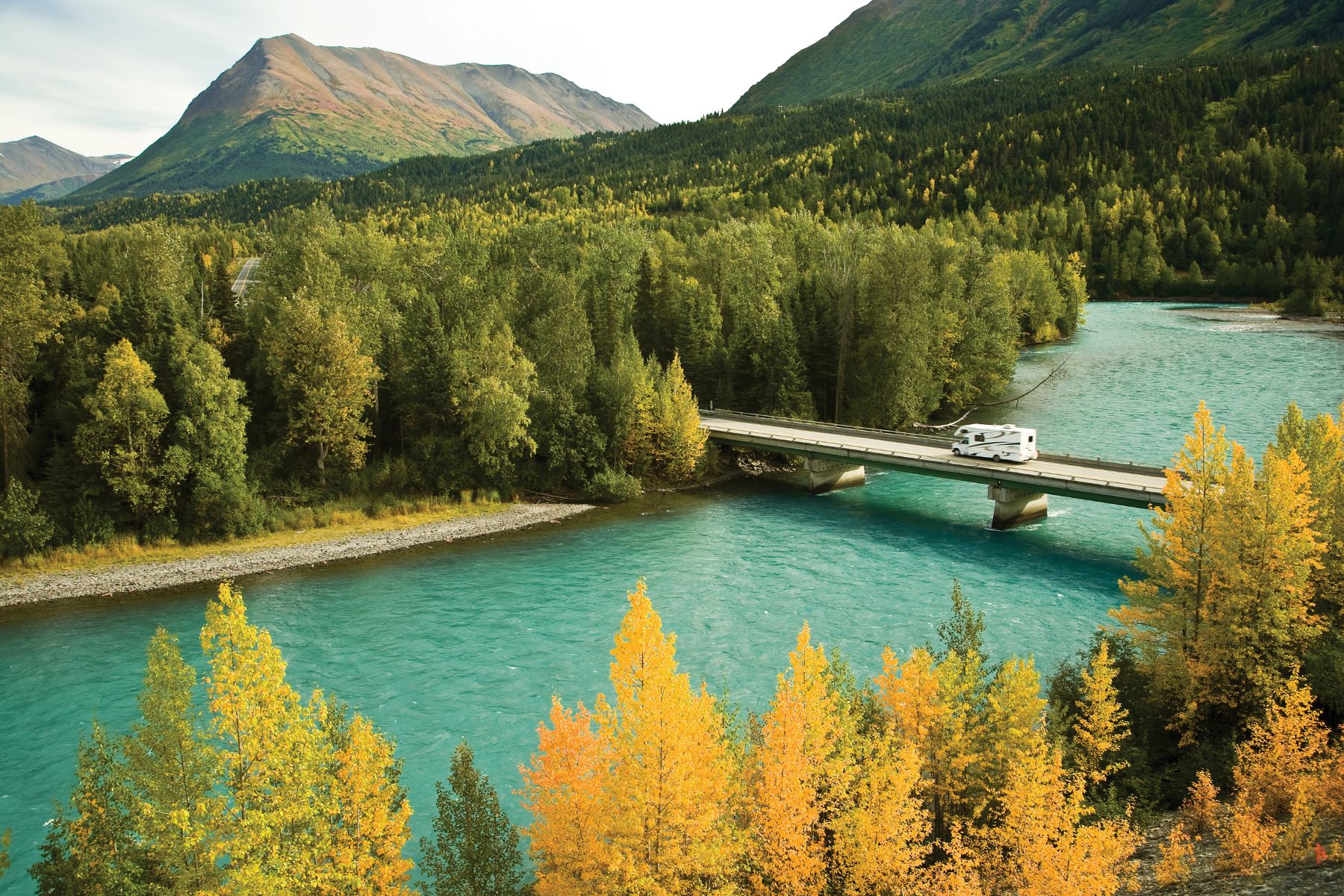
Seward Highway
Begins: Anchorage
Ends: Seward
Distance: 127 miles
Best For: Day trips with stunning views and plenty of services
Running north to south and connecting Anchorage to Seward, the Seward Highway is a true scenic gem. Boasting plenty of spectacular roadside views, the 127 mile-long highway is an official USDA Forest Service Scenic Byway, Alaska Scenic Byway, and All American Road.
It begins in Anchorage, heading south, where views of the Chugach Mountains and Turnagain Arm shoreline grant travelers the opportunity to see beluga whales, waterfalls, eagles, moose, Dall sheep, and more. There are multiple turnout options, giving you a chance to stop and take photos of the majestic coastal views. Potter Marsh Wildlife Viewing Boardwalk, Beluga Point, Bird Point, and multiple hiking trails create an irresistible experience for visitors.
As you head south, you’ll see mountain ranges, alpine glaciers, lakes, rivers, and forests. You’ll have a chance to visit Girdwood, the Alaska Wildlife Conservation Center, Turnagain Pass, and Kenai Lake, and take side trips to the Portage Glacier Area, Whittier, and Hope – or connect to the Sterling Highway for more Kenai Peninsula adventures. The highway ends in Seward, a friendly community known as the gateway to Kenai Fjords National Park, giving you the opportunity to glacier trek, take a day cruise, walk along the shoreline, hike, and more.
Year round, these areas have something to offer visitors. Whether it’s skiing and snowboarding at Alyeska Resort in Girdwood or snowshoeing in the Portage Glacier area in winter, or fishing, berry picking, and epic hiking throughout the summer months, there is so much to enjoy near this highway. This area is teeming with wildlife, so be sure to stay aware on your drive and take it slow to enjoy the views and the entire experience safely. Moose often graze on foliage near the road year-round, so be sure to keep an eye out!

Steese Highway
Begins: Fairbanks
Ends: Circle
Distance: 162 miles
Best For: Gold mining history and Summit views
This scenic highway grants visitors access to the White Mountains National Recreation Area and Birch Creek National Wild & Scenic River, in addition to the Chatanika River, and other natural landmarks. Chena Hot Springs and Circle Hot Springs are also accessible at the end of roads that lead from the Steese Highway. Open year-round, the first 87 miles are paved and the remainder is gravel. Be sure to check road conditions and carry a spare tire when enjoying this road trip!
Traditional homeland to the Athabascan People, the land through which the road travels has been inhabited for thousands of years. There area is rich with gold mining history and has several historical sites along the way, including gold dredges and camps, monuments to early prospectors, and the mining towns of Fox, Circle, and Central. Accommodations along the way include several lodges and campgrounds. Visitors can stretch their legs on hiking trails at Clearly Summit and the Pinnell Mountain National Recreation Trail.
The Steese Highway is renowned for its wildlife viewing opportunities. With rivers, boreal forest, mountains, and tundra, there are a wide array of habitats full of Alaska wildlife. Twelvemile Summit, the Chatanika River, and Eagle Summit are popular wildlife viewing locations. Waterfowl, beavers, moose, bears, fox, and caribou can be seen along the way. Brown and black bears tend to stick to the upland areas where berries and plants grow. Caribou migrate near the road and can be seen at Twelvemile and Eagle Summit Waysides.

Sterling Highway
Begins: near Cooper Landing
Ends: Homer
Distance: 138 miles
Best For: Fishing
The Sterling Highway travels southwest to the Kenai Peninsula, connecting to the Seward Highway just 37 miles north of Seward, near Cooper Landing. Popular fishing locations along this route include sport fishing on the Kenai River and Russian River, where you’ll be able to try your hand at catching a variety of fish including king salmon, depending on the season.
The highway travels through the towns of Cooper Landing, Soldotna, Kenai, Ninilchik, Anchor Point, and ends in Homer, and features breathtaking views of view of Cook Inlet and the volcanoes on the west side of the inlet. Accommodations, recreational activities, food, and other experiences are available all along the way, with opportunities to visit Kenai Lake, Tustumena Lake, Skilak Lake, the Kenai National Wildlife Refuge, and Kachemak Bay.
Taylor Highway
Begins: Tetlin Junction, The Alaska Highway
Ends: Eagle
Distance: 160 miles
Best For: Access to U.S./Canadian border and Fortymile / Yukon River float trips
Known for its connection the Top of the World Highway in Canada’s Yukon Territory, the Taylor Highway begins at Tetlin Junction along the Alaska Highway and travels northeast to the northernmost U.S./Canada Border crossing before ending at the town of Eagle on the Yukon River. This mostly unpaved route boasts a latitude that hits 64.2 at its highest point, just below the Arctic Circle. The 160 mile long rugged and remote route is incredibly unique, with views of the Alaska Range, Mentasta Mountains, and the Fortymile River system. Along the road, the Fortymile National Wild & Scenic River system joins the Yukon River in Canada and creates the perfect opportunity for canoe float trips and rafting in summer months. The Fortymile has many launch points along the way, and the Yukon River is accessible from the town of Eagle.
The Taylor Highway journeys through the traditional homelands of the Athabascan Peoples, where Alaska Native habitation dates back thousands of years. The area also has a deep gold rush history due to the high mineral content in the surrounding mountain ranges. Visitors can learn about the area’s gold rush history, which began in the 1880s, through a landscape that inspired many of Jack London’s novels. Stop by the gold mining town of Chicken, whose namesake was meant to be Ptarmigan, but early settlers were unable to spell the bird’s name, so they settled for a more familiar fowl!
Wildlife here is abundant, including caribou that frequent the area during summer migration, peregrine falcons, moose, black bears, brown bears, red fox, gray wolves, lynx, short-eared owls, and more. Close proximity to the Yukon Charley Rivers National Preserve and wide alpine tundra provide the perfect habitat for wildlife.
There are three first-come, first-serve BLM campgrounds along the Taylor Highway, along with lodging and services in the small towns of Eagle and Chicken. This seasonal road is mostly unpaved and closed October through April. Check with your rental car company for any road restrictions before planning a trip on the Taylor Highway.

Highways and Scenic Byways to Remember
These highways offer you incredible access to some the most stunning scenery the state has to offer. If you are planning an Alaska road trip, we recommend getting a copy of The Milepost, a comprehensive, mile-by-mile guide to Alaska’s highways, including maps and detailed information on services and attractions along the way. While there are many ways to journey through our landscape, taking a road trip on Alaska’s highways is an excellent way to experience Alaska up close on your own schedule!
Learn more about driving in Alaska.


Alaska: AKA Your Next Adventure
Where will your Alaska adventure take you? Order our Official State of Alaska Vacation Planner and plot your course.