
Getting To & Around Alaska: Drive
Driving to Alaska through Canada or flying to Alaska and embarking on an epic Alaska road trip are high on the list of many adventurers. Alaska road trips are legendary for their beauty and access to top sights as well as off-the-beaten track destinations. Driving the famed Alaska Highway in a car or RV offers the opportunity to linger along the way. Some of the world’s wildest and most beautiful national and state parks are along this route. Cultural attractions, adventure tours, incredible scenery, and unforgettable experiences make this option popular with independent travelers.
DRIVING TO ALASKA FROM SEATTLE, WA
The Alaska Highway is a modern, well-maintained highway stretching 1,387 miles from Canada’s British Columbia through the Yukon and ending in Delta Junction in Interior Alaska. Construction occurs seasonally and may cause delays in small sections, but otherwise, it’s smooth driving! Particularly in summer, visitor amenities including gas, food, and motels are abundant along the entire Alaska Highway. Most visitors cross the border into Canada north of Seattle, WA, though there are other routes further east through Alberta and the Canadian Rockies for those who are starting from the eastern United States.
There are two route options for getting from Seattle to the Alaska Highway. Both routes head north from Seattle to the town of Prince George, British Columbia. From Prince George you can head to Highway 97 to connect to the Alaska Highway at Dawson Creek, or take the more remote Cassiar Highway to connect to the Alaska Highway near Watson Lake.
The Highway 97/Alaska Highway route is 100 miles longer than the Cassiar Highway but it’s typically the faster route. It is less remote and has more amenities along the way, and allows you to experience the entire Alaska Highway from "Mile 0" at Dawson Creek. If you have a little more time and are looking for a more remote experience, the Cassiar Highway offers less traffic and better wildlife viewing opportunities. In many sections, the Cassiar Highway is a two lane road and speed limits are slower. Both options will take you through beautiful scenery in British Columbia before joining up near Watson Lake in the Yukon Territory. From there, you’ll travel along the Alaska Highway through Whitehorse and then on to the border crossing, where your Alaska adventure will officially begin.
The driving distance from Seattle to the Yukon Territory/Alaska border crossing is about 1,800 – 1,900 miles, depending on which route you take. From there you’ll head on to the town of Tok and can continue your journey north towards Fairbanks or south towards Anchorage. While you can make the drive in as little as 3 days, we recommend planning for a week of driving so you can take your time and fully experience the stunning scenery, campgrounds, lodges, and wildlife along the way.
Ready to start planning your journey North to Alaska? Check out our detailed route descriptions, maps, and rules/FAQs for driving through Canada.
ALASKA MARINE HIGHWAY SYSTEM
A strictly pavement approach isn’t the only option. Travelers can also board the Alaska ferry system, called the Alaska Marine Highway, in Bellingham, Wash. or Prince Rupert, B.C. with cars or RVs. From Vancouver Island, travelers can connect with Prince Rupert via the BC Ferry. This route travels through the coastal communities of Alaska’s Inside Passage, where road trippers can disembark in Skagway or Haines to connect to the road system in the Yukon, and then finish the journey to Alaska on the Alaska Highway. Ferry travelers can also connect to over 35 port communities along the Alaska Marine Highway route in Alaska's Inside Passage, Southcentral, and Southwest regions.
DRIVING THE ALASKA HIGHWAY IN WINTER
The best driving conditions, most hours of daylight, and most visitor services can be found on the Alaska Highway from May through September. However, visitors can have a fun and safe drive along the Alaska Highway year-round with a little extra caution and advance planning. While roads are less busy in winter, conditions can be icy and snowy along the route, especially in the Yukon and Interior Alaska. Be sure to give yourself extra time for weather and icy road conditions. Studded tires are recommended, and winter tires are required in British Columbia from October 1 – March 31.
Some visitor services like lodges, stores, and activities are not open in winter. Before your trip, be sure to check which services are open year-round and have a back-up plan for accommodations if you have to wait out bad weather. Extreme cold temperatures are common in winter so be prepared with emergency cold weather gear in case you encounter any car troubles. Fuel up on gas as often as possible as some gas stations have limited hours in winter.
DRIVING IN ALASKA
Driving in Alaska allows you the freedom to explore at your own pace. Weather you drive from the Lower 48 on the Alaska Highway, bring your vehicle on the Alaska Marine Highway System, or rent a car or RV once you arrive, you will find endless opportunities for road trip adventures in the state. Scenic views of towering mountains and sparkling glaciers are abundant along Alaska’s highways, as well as up-close encounters with wildlife like sheep, eagles, and moose — right from the road. Many popular destinations and visitor attractions in Alaska are primarily accessible by highway, including Denali National Park and Preserve, Kenai Fjords National Park, Seward, Homer, Anchorage, Talkeetna, Valdez, Fairbanks, and more. The state may be big, but it's simple to navigate by road. Driving yourself gives you the freedom to get off the beaten track, take your time, and discover more of Alaska's remote towns, trails, and attractions.
Car and RV rentals are available in most Alaska cities. Services like gas, food, campsites and RV parks, and other lodging are plentiful along main highways. Many of these roadways are recognized for their remarkable scenery, history, and cultural significance by the National Scenic Byways program. Alaska also has two All-American Roads, the highest level of federal recognition available. The first is the Seward Highway, stretching from Anchorage to Seward in Southcentral Alaska. The second is the entire route of the Alaska Marine Highway System.
There are a variety of resources for travelers who choose to see Alaska by road. The Milepost, a comprehensive, mile-by-mile guide to Alaska’s highways, includes maps and detailed information on services and attractions along the way. For updates on road conditions and public access restrictions, consult the State of Alaska Department of Transportation website.
The best driving conditions and access to the most visitor services, lodging, and tour options can be found in the summer, from May through September. Most communities on the road system are accessible year-round but be prepared for icy and snowy conditions when driving in winter. Studded tires are allowed from September 15 – May 1. Keep your headlights on, take it slow, and be sure to leave plenty of space between your vehicle and the one in front of you. Alaska’s major highways and roads are maintained in winter but some of the more remote roads are not. There are a few unpaved roads in Alaska that lead to smaller communities and remote locations. These include the Denali Highway, Dalton Highway, Top of the World Highway, and the McCarthy Road. Portions of the Steese and Taylor Highways are also unpaved. Most rental car companies do not allow vehicles to drive on unpaved roads, so keep that in mind when planning your Alaska road trip.
Explore detailed route descriptions, maps, and rules/FAQs for driving to Alaska through Canada.
Plan Your Trip

River Wild was formed for wanderlust souls. We are seeking to change the way tourism is done in Alaska by providing opportunities to explore its...
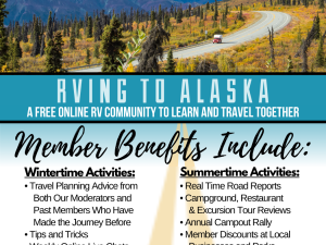
RVing to Alaska LLC is an online collaboration of RVers sharing our travels and learning together. We are not a caravan company or give online...

From breathtaking scenic coach tours to the iconic Alaska Rail Road and self-drive packages – we have every option covered to complete your dream...


Are you looking for a vehicle for your self-drive tour through Alaska, the Yukon Territory and Western Canada? GoNorth rents truck campers...

Discover the difference renting an RV from Great Alaskan Holidays can make on your next Alaskan adventure. We offer a relaxed vacation in the...

Navigate Alaska
Alaska is a land of superlatives and adventure. Explore five distinct regions and varied travel routes and modes of transportation as you plan your Alaska getaway.
Map Views
Explore by Region
-
×
Arctic

Alaska’s far north features the country’s only Arctic ecosystem; northern lights dance above the snowy tundra in winter, while birds and caribou graze during long summer days.
-
×
Inside Passage
The Inside Passage in Southeast Alaska is home to breathtaking temperate rainforests, protected waterways, and glaciers reaching into deep coastal fjords.
-
×
Interior
The Interior Region is a quintessentially Alaska landscape, bounded by high mountain ranges (it’s home to Denali) and crisscrossed by glorious river vistas.
-
×
Southcentral
Southcentral Alaska is home to vividly diverse wilderness landscapes – from beaches to mountaintops to fjords – as well as half the state’s population.
-
×
Southwest
Southwest Alaska’s islands, river deltas, and mountains teem with fish and wildlife.
Alaska: AKA Your Next Adventure
Where will your Alaska adventure take you? Order our Official State of Alaska Vacation Planner and plot your course.
Travel Inspiration
#TravelAlaska
#TravelAlaska
 @johnpei5624
 @johnpei5624
 @rehmat.orakzai
 @valerievalise
 @johnpei5624


